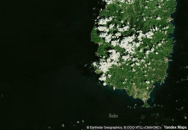
Pitons Management Area
near the town of Soufriere, southwestern region of St Lucia
|

|
Identifier |
1161 |
|

|
states |
lc |
|

|
category |
natural |
|

|
criteria |
(vii)(viii) |
|

|
Title |
pitons management area |
|

|
latitude |
13.8070831299 |
|

|
longitude |
-61.0703620911 |
|

|
location |
near the town of soufriere, southwestern region of st lucia |
|

|
Region |
latin america and the caribbean |
|

|
year |
2004 |
|

|
unique number |
1341 |
|

|
description |
the 2,909-ha site near the town of soufriere includes the pitons, two volcanic spires rising side by side from the sea (770 m and 743 m high respectively), linked by the piton mitan ridge. the volcanic complex includes a geothermal field with sulphurous fumeroles and hot springs. coral reefs cover almost 60% of the site’s marine area. a survey has revealed 168 species of finfish, 60 species of cnidaria, including corals, eight molluscs, 14 sponges, 11 echinoderms, 15 arthropods and eight annelid worms. the dominant terrestrial vegetation is tropical moist forest grading to subtropical wet forest, with small areas of dry forest and wet elfin woodland on the summits. at least 148 plant species have been recorded on gros piton, 97 on petit piton and the intervening ridge, among them eight rare tree species. the gros piton is home to some 27 bird species (five of them endemic), three indigenous rodents, one opossum, three bats, eight reptiles and three amphibians. |
|

|
justification |
criterion (viii): the pitons management area contains the greater part of a collapsed stratovolcano contained within the volcanic system, known to geologists as the soufriere volcanic centre. prominent within the volcanic landscape are two eroded remnants of lava domes, gros piton and petit piton. the pitons occur with a variety of other volcanic features including cumulo-domes, explosion craters, pyroclastic deposits (pumice and ash), and lava flows. collectively, these fully illustrate the volcanic history of an andesitic composite volcano associated with crustal plate subduction.
criterion (vii): the pitons management area derives its primary visual impact and aesthetic qualities from the pitons, two adjacent forest-clad volcanic lava domes rising abruptly from the sea to heights greater than 700m. the pitons predominate over the st lucian landscape, being visible from virtually every part of the island and providing a distinctive landmark for seafarers.the combination of the pitons against the backdrop of green tropical vegetation and a varying topography combined with a marine foreground gives the area its superlative beauty. |
|


 0
0


 1 X ™ unesco
 Info
Info
 Map
Map
 similar
 language