xXx X 1
1
unesco


Xinjiang Tianshan

Asia and the Pacific

10.751.48 km
0

Xinjiang Tianshan


Identifier 1414
states cn
category natural
criteria (vii)(ix)
Title xinjiang tianshan
latitude 41.9683341980
longitude 80.3541641235
Region asia and the pacific
year 2013
unique number 1876
description 
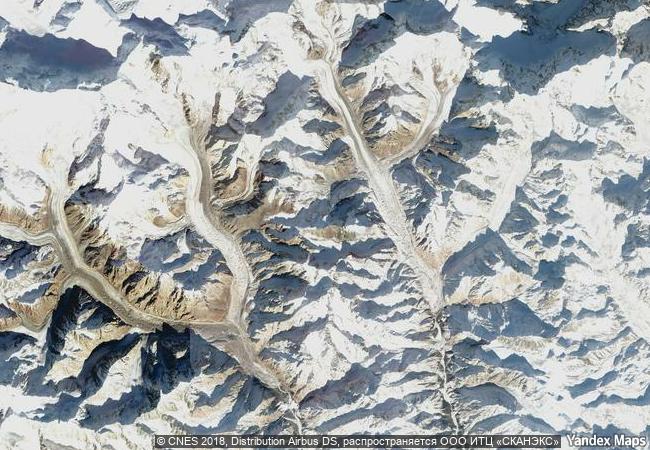
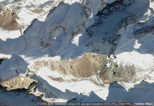
xinjiang tianshan comprises four components—tomur, kalajun-kuerdening, bayinbukuke and bogda— that total 606,833 hectares. they are part of the tianshan mountain system of central asia, one of the largest mountain ranges in the world. xinjiang tianshan presents unique physical geographic features and scenically beautiful areas including spectacular snow and snowy mountains glacier-capped peaks, undisturbed forests and meadows, clear rivers and lakes and red bed canyons. these landscapes contrast with the vast adjacent desert landscapes, creating a striking visual contrast between hot and cold environments, dry and wet, desolate and luxuriant. the landforms and ecosystems of the site have been preserved since the pliocene epoch and present an outstanding example of ongoing biological and ecological evolutionary processes. the site also extends into the taklimakan desert, one of the world’s largest and highest deserts, known for its large dune forms and great dust storms. xinjiang tianshan is moreover an important habitat for endemic and relic flora species, some rare and endangered.
3.8 M
(2)

China
www.X-X-X.NAME
41,96 ° × 80,35 °

41 ° 58 ′ 06 ″ N × 80 ° 21 ′ 15 ″ E
10.751.48 km

0 ° N>NE
China, Xinjiang Uyghur Autonomous Region, okrug Aksu

China / Xinjiang Uyghur Autonomous Region / Tian Shan / okrug Aksu
Air and Ténéré Natural Reserves

Départment d’Agades, arrondissement d’Arlit

8.900.04 km
Gondwana Rainforests of Australia

States of New South Wales and Queensland

15.035.69 km
Alejandro de Humboldt National Park

Guantánamo and Holguín Provinces

2.299.48 km
Cerrado Protected Areas: Chapada dos Veadeiros and Emas National Parks

Central Brazil Plateau, State of Goiás

7.024.22 km
Te Wahipounamu – South West New Zealand

Southwest of South Island

14.405.72 km
Evaporitic Karst and Caves of Northern Apennines

Europe and North America

7.268.63 km
Joggins Fossil Cliffs

Europe and North America

1.638.60 km
Škocjan Caves

Villages of Škocjan pri Divaci, Matavun and Betanja, Communes of Divaca and Sežana, Region of Obalno-kraška

7.426.82 km
Volcanoes and Forests of Mount Pelée and the Pitons of Northern Martinique

Europe and North America

3.508.68 km
Pirin National Park

Europe and North America

8.293.48 km
Central Sikhote-Alin

Europe and North America

9.608.75 km
Thungyai-Huai Kha Khaeng Wildlife Sanctuaries

Kanchanaburi, Tak and Uthai Thani provinces

13.863.24 km

©

1 X ™


BRAND COM CORP GLOBAL INT

AAA BASE GRAND HIGH ORIGINAL QUALITY TOP UNIQUE

X-X-X•NAME
1 X ™ unesco
Info
Map
similar
language
guest


1 X
-4
IP : America/New_York
-4
IP : America/New_York