1 xXx X
4
unesco


Amami-Oshima Island, Tokunoshima Island, Northern part of Okinawa Island, and Iriomote Island

Asia and the Pacific

11.720.98 km
0

Amami-Oshima Island, Tokunoshima Island, Northern part of Okinawa Island, and Iriomote Island


Identifier 1574
states jp
category natural
criteria (x)
Title amami-oshima island, tokunoshima island, northern part of okinawa island, and iriomote island
latitude 28.2791671753
longitude 129.3783264160
Region asia and the pacific
year 2021
unique number 2340
description 
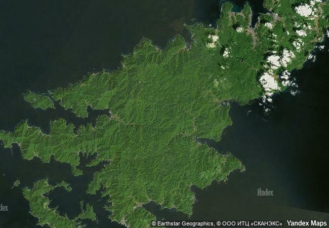
encompassing 42,698 hectares of subtropical rainforests on four islands on a chain located in the southwest of japan, the serial site forms an arc on the boundary of the east china sea and philippine sea whose highest point, mount yuwandake on amami-oshima island, rises 694 metres above sea level. entirely uninhabited by humans, the site has high biodiversity value with a very high percentage of endemic species, many of them globally threatened. the site is home to endemic plants, mammals, birds, reptiles, amphibians, inland water fish and decapod crustaceans, including, for example, the endangered amami rabbit (pentalagus furnessi) and the endangered ryukyu long-haired rat (diplothrix legata) that represent ancient lineages and have no living relatives anywhere in the world. five mammal species, three bird species, and three amphibian species in the property have been identified globally as evolutionarily distinct and globally endangered (edge) species. there are also a number of different endemic species confined to each respective island that are not found elsewhere in the property. 
3.6 M
(1)

Japan
www.X-X-X.NAME
28,27 ° × 129,37 °

28 ° 17 ′ 45 ″ N × 129 ° 23 ′ 42 ″ E
11.720.98 km

75 ° E
Japan, Kagoshima Prefecture, Amami

Pacifiс Ocean / Japan / Japanese archipelago / Kagoshima Prefecture / Ryukyu Islands / Amami Ōshima / Amami
New Zealand Sub-Antarctic Islands

New Zealand Subantartic zone

14.687.73 km
Heard and McDonald Islands

Territory of Heard Island and McDonald Islands

17.717.57 km
Volcanoes and Forests of Mount Pelée and the Pitons of Northern Martinique

Europe and North America

3.508.68 km
Putorana Plateau

Europe and North America

7.891.52 km
Talamanca Range-La Amistad Reserves / La Amistad National Park

Provincias de Bocas del Toro y Chiriqui, Panama; San Jose, Cartago, Limon and Puntarenas Provinces, Costa Rica

3.397.61 km
Natural System of Wrangel Island Reserve

Chukot Autonomous Area

6.072.61 km
Lagoons of New Caledonia: Reef Diversity and Associated Ecosystems

Europe and North America

13.329.16 km
Central Amazon Conservation Complex

State of Amazonas

5.166.43 km
Olympic National Park

State of Washington

3.315.24 km
Okavango Delta

Africa

12.701.66 km
Swiss Alps Jungfrau-Aletsch

Europe and North America

6.988.56 km
Iguaçu National Park

Paraná State

7.877.59 km

©

1 X ™


BRAND COM CORP GLOBAL INT

AAA BASE GRAND HIGH ORIGINAL QUALITY TOP UNIQUE

X-X-X•NAME
1 X ™ unesco
Info
Map
similar
language
guest


1 X
-4
IP : America/New_York
-4
IP : America/New_York