X 1 xXx ™
1
⬤
unesco
⬤


☆
Persepolis

Fars

11.008.16 km
☆
★★★★☆
0

Persepolis


Fars
Identifier 114
states ir
category cultural
criteria (i)(iii)(vi)
Title persepolis
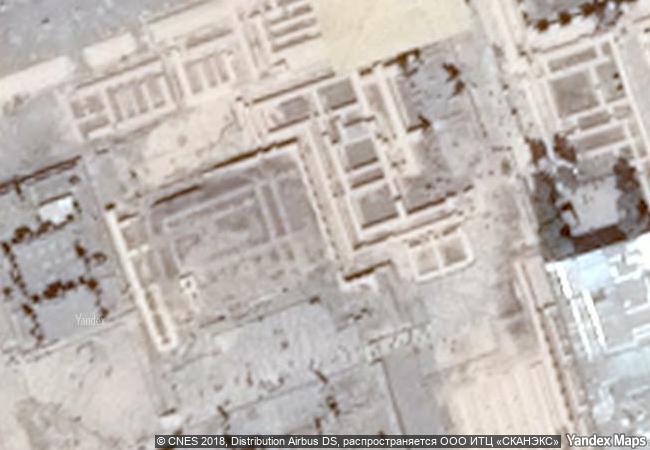
latitude 29.9344406128
longitude 52.8902816772
location fars
Region asia and the pacific
year 1979
unique number 123
description founded by darius i in 518 b.c., persepolis was the capital of the achaemenid empire. it was built on an immense half-artificial, half-natural terrace, where the king of kings created an impressive palace complex inspired by mesopotamian models. the importance and quality of the monumental ruins make it a unique archaeological site.
★
7.6 M
(1)

Iran
www.X-X-X.NAME
29,93 ° × 52,89 °

29 ° 56 ′ 04 ″ N × 52 ° 53 ′ 25 ″ E
11.008.16 km

354 ° N
Iran, Fars Province

Iran / Zagros Mountains / Fars Province
☆
Saint Hilarion Monastery/ Tell Umm Amer

Arab States

9.787.64 km
☆
Historic Centre of the Town of Goiás

State of Goiás

7.085.11 km
☆
Seokguram Grotto and Bulguksa Temple

Asia and the Pacific

10.964.39 km
★
Site of Palmyra

Province of Homs

9.773.95 km
☆
Ajanta Caves

Maharashtra State, Aurangabad District , Soyagon Taluka, Lenapur Village

12.932.72 km
☆
Orkhon Valley Cultural Landscape

Orkhon-Kharkorin Region

10.275.95 km
☆
Sassanid Archaeological Landscape of Fars Region

Asia and the Pacific

10.953.27 km
☆
Naval Port of Karlskrona

Blekinge County

6.891.54 km
☆
The Four Lifts on the Canal du Centre and their Environs, La Louvière and Le Roeulx (Hainaut)

Europe and North America

6.524.85 km
☆
Rangiri Dambulla Cave Temple

Central Province, Matale District

14.438.63 km
☆
Koutammakou, the Land of the Batammariba

Africa

8.784.89 km
☆
Cultural Landscape of Old Tea Forests of the Jingmai Mountain in Pu’er

Asia and the Pacific

13.097.80 km

©

1 X ™


BRAND • COM • CORP • GLOBAL • INT

AAA • BASE • GRAND • HIGH • ORIGINAL • QUALITY • TOP • UNIQUE

™X-X-X•NAME
1 X ™ unesco
Info
Map
similar
language
▼ ▼ ▼
guest


1 X
™
-4
IP : America/New_York
-4
IP : America/New_York
▼ ▼ ▼
►
►