X 1 xXx
unesco


Roșia Montană Mining Landscape

Europe and North America

7.950.86 km
0

Roșia Montană Mining Landscape


Identifier 1552
states ro
category cultural
criteria (ii)(iii)(iv)
Title roșia montană mining landscape
latitude 46.3061103821
longitude 23.1305561066
Region europe and north america
year 2021
unique number 2402
description 
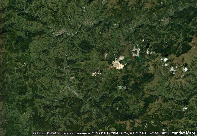
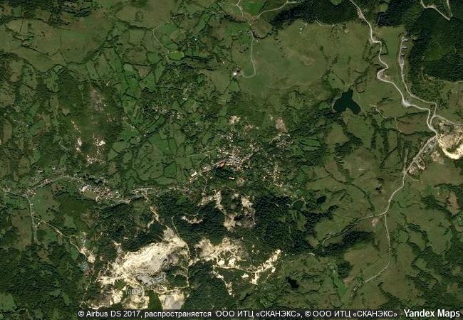
located in the metalliferous range of the apuseni mountains in the west of romania, roșia montană features the most significant, extensive and technically diverse underground roman gold mining complex known at the time of inscription. as alburnus maior, it was the site of extensive gold-mining during the roman empire. over 166 years starting in 106 ce, the romans extracted some 500 tonnes of gold from the site developing highly engineered works, different types of galleries totalling 7km and a number of waterwheels in four underground localities chosen for their high-grade ore. wax‐coated wooden writing tablets have provided detailed legal, socio‐economic, demographic and linguistic information about the roman mining activities, not just in alburnus maior but also across the wider dacian province. the site demonstrates a fusion of imported roman mining technology with locally developed techniques, unknown elsewhere from such an early era. mining on the site was also carried out, albeit to a lesser extent, between medieval times and the modern era. the later extractive works surround and cut across the roman galleries. the ensemble is set in an agro-pastoral landscape which largely reflects the structures of the communities that supported the mines between the 18th and early 20th centuries.
7.26 M

Romania
www.X-X-X.NAME
46,30 ° × 23,13 °

46 ° 18 ′ 22 ″ N × 23 ° 08 ′ 50 ″ E
7.950.86 km

97 ° E>SE
Romania, Alba

Romania / Carpathian Mountains / Alba
18th-Century Royal Palace at Caserta with the Park, the Aqueduct of Vanvitelli, and the San Leucio Complex

Provinces of Caserta and Benevento, Campania

7.741.33 km
Masjed-e Jāmé of Isfahan

Asia and the Pacific

10.690.95 km
Historic Centre of the City of Salzburg

Salzburg

7.235.14 km
Sulaiman-Too Sacred Mountain

Asia and the Pacific

10.734.88 km
Major Town Houses of the Architect Victor Horta (Brussels)

Europe and North America

6.522.33 km
Alto Douro Wine Region

Douro Region, Trás-os-Montes e Alto Douro

6.145.79 km
Paleochristian and Byzantine Monuments of Thessalonika

Prefecture of Thessaloniki, Region of Central Macedonia

8.343.20 km
Buddhist Monuments in the Horyu-ji Area

Nara Prefecture

10.819.72 km
Tusi Sites

Asia and the Pacific

12.230.56 km
Wooden Churches of Southern Małopolska

Gorlice, Nowy Targ, and Bochnia counties, Voivodship of Lesser Poland (Malopolskie); Brzozów County, Subcarpathian (Podkarpackie) Voivodship

7.603.85 km
Hatra

Governorate of Ninawa

9.944.85 km
Medina of Marrakesh

Province of Marrakesh

6.630.86 km

©

1 X ™


BRAND COM CORP GLOBAL INT

AAA BASE GRAND HIGH ORIGINAL QUALITY TOP UNIQUE

X-X-X•NAME
1 X ™ unesco
Info
Map
similar
language
guest


1 X
-4
IP : America/New_York
-4
IP : America/New_York