X 1 xXx
unesco


Budj Bim Cultural Landscape

Asia and the Pacific

16.172.52 km
0

Budj Bim Cultural Landscape


Identifier 1577
states au
category cultural
criteria (iii)(v)
Title budj bim cultural landscape
latitude -38.0811119080
longitude 141.8852844238
Region asia and the pacific
year 2019
unique number 2262
description 
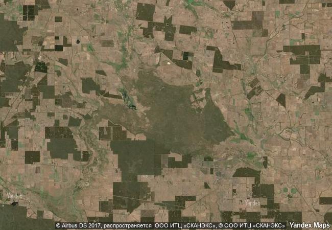
the budj bim cultural landscape, located in the traditional country of the gunditjmara people in south-eastern australia, consists of three serial components containing one of the world’s most extensive and oldest aquaculture systems. the budj bim lava flows provide the basis for the complex system of channels, weirs and dams developed by the gunditjmara in order to trap, store and harvest kooyang (short-finned eel – anguilla australis). the highly productive aquaculture system provided an economic and social base for gunditjmara society for six millennia. the budj bim cultural landscape is the result of a creational process narrated by the gunditjmara as a deep time story, referring to the idea that they have always lived there. from an archaeological perspective, deep time represents a period of at least 32,000 years. the ongoing dynamic relationship of gunditjmara and their land is nowadays carried by knowledge systems retained through oral transmission and continuity of cultural practice.
6.7 M

Australia
www.X-X-X.NAME
-38,08 ° × 141,88 °

38 ° 05 ′ 52 ″ S × 141 ° 53 ′ 07 ″ E
16.172.52 km

273 ° W>NW
Australia, Victoria

Australia / Victoria
Gusuku Sites and Related Properties of the Kingdom of Ryukyu

Okinawa Prefecture

12.000.23 km
Cidade Velha, Historic Centre of Ribeira Grande

Africa

6.355.68 km
Le Colline del Prosecco di Conegliano e Valdobbiadene

Europe and North America

7.294.69 km
Wooden Churches of Southern Małopolska

Gorlice, Nowy Targ, and Bochnia counties, Voivodship of Lesser Poland (Malopolskie); Brzozów County, Subcarpathian (Podkarpackie) Voivodship

7.603.85 km
Sites of Human Evolution at Mount Carmel: The Nahal Me’arot / Wadi el-Mughara Caves

Europe and North America

9.726.87 km
Tower of London

London Borough of Tower Hamlets, England

6.209.70 km
Island of Mozambique

Ilha de Mocambique District, Nampula Province

13.932.03 km
Abbey of St Gall

Canton of St Gall, Town of St Gall

7.023.84 km
Trans-Iranian Railway

Asia and the Pacific

10.398.55 km
Trinidad and the Valley de los Ingenios

Province of Sancti Spiritus

2.039.36 km
Major Mining Sites of Wallonia

Europe and North America

6.508.50 km
Mogao Caves

Dunhuang County, Gansu Province. At the eastern foot of Mount Mingsha, 25 kilometres southeast of the County seat.

11.106.10 km

©

1 X ™


BRAND COM CORP GLOBAL INT

AAA BASE GRAND HIGH ORIGINAL QUALITY TOP UNIQUE

X-X-X•NAME
1 X ™ unesco
Info
Map
similar
language
guest


1 X
-4
IP : America/New_York
-4
IP : America/New_York