xXx X 1
4
unesco


Chankillo Archaeoastronomical Complex

Latin America and the Caribbean

5.528.19 km
0

Chankillo Archaeoastronomical Complex


Identifier 1624
states pe
category cultural
criteria (i)(iv)
Title chankillo archaeoastronomical complex
latitude -9.5568609238
longitude -78.2359161377
Region latin america and the caribbean
year 2021
unique number 2348
description 
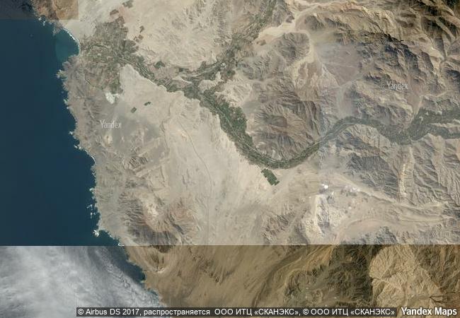
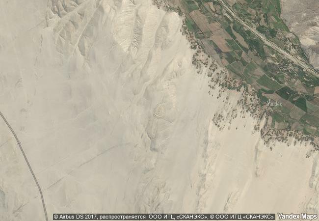
the chankillo archaeoastronomical complex is a prehistoric site (250-200 bc), located on the north-central coast of peru, in the casma valley, comprising a set of constructions in a desert landscape that, together with natural features, functioned as a calendrical instrument, using the sun to define dates throughout the year. the site includes a triple-walled hilltop complex, known as the fortified temple, two building complexes called observatory and administrative centre, a line of 13 cuboidal towers stretching along the ridge of a hill, and the cerro mucho malo that complements the thirteen towers as a natural marker. the ceremonial centre was probably dedicated to a solar cult, and the presence of an observation point on either side of the north-south line of the thirteen towers allows the observation both of the solar rising and setting points throughout the whole year. the site shows great innovation by using the solar cycle and an artificial horizon to mark the solstices, the equinoxes, and every other date within the year with a precision of 1-2 days. it is thus a testimony of the culmination of a long historical evolution of astronomical practices in the casma valley. 
2.49 M

Peru
www.X-X-X.NAME
-9.5568609238 ° × -78.2359161377 °

9 ° 33 ′ 25 ″ S × 78 ° 14 ′ 09 ″ W
5.528.19 km

92 ° E>SE
Peru, Departamento de Áncash, Provincia de Casma

Andes / Peru / Departamento de Áncash / Provincia de Casma
ShUM Sites of Speyer, Worms and Mainz

Europe and North America

6.858.09 km
Routes of Santiago de Compostela in France

Regions of Aquitaine, Auvergne, Basse-Normandie, Bourgogne, Centre, Champagne-Ardenne, Ile-de-France, Languedoc-Roussillon, Limousin, Midi-Pyrénées, Picardie, Poitou-Charentes, and Provence-Alpes-Côte d’Azur

6.563.52 km
Historic Centre of Zacatecas

Zacatecas State, Zacatecas Municipality

2.653.18 km
Ancient City of Bosra

Governorate of Deraa

9.834.69 km
Anjar

District of Zahle, Beqaa Governorate

9.700.17 km
Medici Villas and Gardens in Tuscany

Europe and North America

7.361.53 km
Historic Jeddah, the Gate to Makkah

Arab States

10.933.03 km
Twyfelfontein or /Ui-//aes

Kunene Region

12.069.85 km
Djerba: Testimony to a settlement pattern in an island territory

Arab States

7.981.44 km
Royal Tombs of the Joseon Dynasty

Asia and the Pacific

10.854.15 km
Neolithic Flint Mines at Spiennes (Mons)

Province of Hainaut, Wallonia Region

6.518.39 km
Asmara: A Modernist African City

Africa

11.428.58 km

©

1 X ™


BRAND COM CORP GLOBAL INT

AAA BASE GRAND HIGH ORIGINAL QUALITY TOP UNIQUE

X-X-X•NAME
1 X ™ unesco
Info
Map
similar
language
guest


1 X
-4
IP : America/New_York
-4
IP : America/New_York