1 xXx X
2
unesco


Dholavira: a Harappan City

Asia and the Pacific

12.391.64 km
0

Dholavira: a Harappan City


Identifier 1645
states in
category cultural
criteria (iii)(iv)
Title dholavira: a harappan city
latitude 23.8884086609
longitude 70.2133026123
Region asia and the pacific
year 2021
unique number 2386
description 
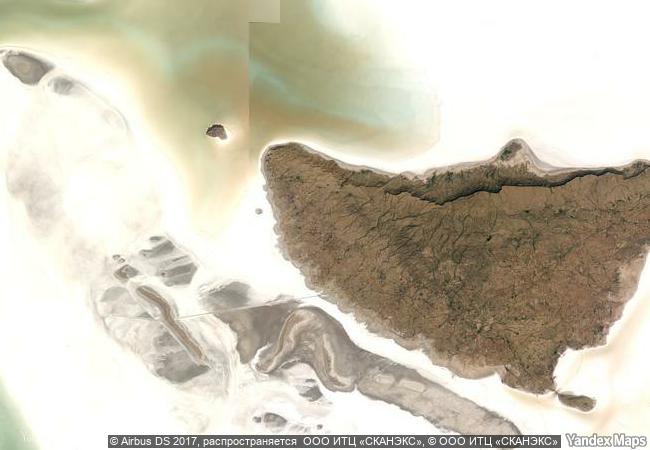
the ancient city of dholavira, the southern centre of the harappan civilization, is sited on the arid island of khadir in the state of gujarat. occupied between ca. 3000-1500 bce, the archaeological site, one of the best preserved urban settlements from the period in southeast asia, comprises a fortified city and a cemetery. two seasonal streams provided water, a scarce resource in the region, to the walled city which comprises a heavily fortified castle and ceremonial ground as well as streets and houses of different proportion quality which testify to a stratified social order. a sophisticated water management system demonstrates the ingenuity of the dholavira people in their struggle to survive and thrive in a harsh environment. the site includes a large cemetery with cenotaphs of six types testifying to the harappan’s unique view of death. bead processing workshops and artifacts of various kinds such as copper, shell, stone, jewellery of semi-precious stones, terracotta, gold, ivory and other materials have been found during archaeological excavations of the site, exhibiting the culture’s artistic and technological achievements. evidence for inter-regional trade with other harappan cities, as well as with cities in the mesopotamia region and the oman peninsula have also been discovered. 
4.03 M

India
www.X-X-X.NAME
23.8884086609 ° × 70.2133026123 °

23 ° 53 ′ 18 ″ N × 70 ° 13 ′ 48 ″ E
12.391.64 km

14 ° N>NE
India, State of Gujarat, Khadir Island

India / State of Gujarat / Great Rann of Kutch / Kutch Desert Wildlife Sanctuary / Khadir Island
Birka and Hovgården

Stockholm County (Region of Uppland)

6.811.27 km
Incense Route - Desert Cities in the Negev

Negev Region

9.900.91 km
Churches of Peace in Jawor and Świdnica

Jawor and Świdnica counties, Lower Silesian (Dolnoslaskie) Voivodship

7.228.59 km
Ancient Ksour of Ouadane, Chinguetti, Tichitt and Oualata

Oudane, Chinguetti: region de l’Adrar; Tichitt: region du Tagant; Oualata: region du Hodh Echchargut

6.976.72 km
Cultural Landscape of Maymand

Asia and the Pacific

11.112.81 km
Baalbek

City and District of Baalbek, Beqaa Governorate

9.694.28 km
Tokaj Wine Region Historic Cultural Landscape

County of Borsod-Abaúj-Zemplén

7.718.28 km
Gobustan Rock Art Cultural Landscape

Garadagh District and Apsheron District, Baku City Administrative Territory

9.887.24 km
Cathedral and Churches of Echmiatsin and the Archaeological Site of Zvartnots

Armavir Region

9.629.91 km
Chief Roi Mata’s Domain

Asia and the Pacific

12.840.18 km
Aphrodisias

Europe and North America

8.929.84 km
Island of Gorée

Cape Verde Region

6.898.35 km

©

1 X ™


BRAND COM CORP GLOBAL INT

AAA BASE GRAND HIGH ORIGINAL QUALITY TOP UNIQUE

X-X-X•NAME
1 X ™ unesco
Info
Map
similar
language
guest


1 X
-4
IP : America/New_York
-4
IP : America/New_York