xXx 1 X
4
unesco


West Norwegian Fjords – Geirangerfjord and Nærøyfjord

Counties of Møre & Romsdal and Sogn & Fjordane

6.169.53 km
0

West Norwegian Fjords – Geirangerfjord and Nærøyfjord


Counties of Møre & Romsdal and Sogn & Fjordane
Identifier 1195
states no
category natural
criteria (vii)(viii)
Title west norwegian fjords – geirangerfjord and nærøyfjord
latitude 62.1166687012
longitude 7.1666698456
location counties of møre & romsdal and sogn & fjordane
Region europe and north america
year 2005
unique number 1372
description 
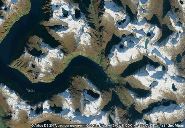
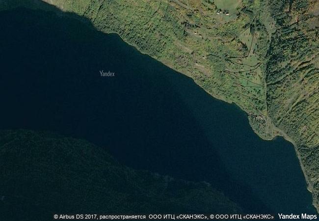
situated in south-western norway, north-east of bergen, geirangerfjord and nærøyfjord, set 120 km from one another, are part of the west norwegian fjord landscape, which stretches from stavanger in the south to andalsnes, 500 km to the north-east. the two fjords, among the world’s longest and deepest, are considered as archetypical fjord landscapes and among the most scenically outstanding anywhere. their exceptional natural beauty is derived from their narrow and steep-sided crystalline rock walls that rise up to 1,400 m from the norwegian sea and extend 500 m below sea level. the sheer walls of the fjords have numerous waterfalls while free-flowing rivers cross their deciduous and coniferous forests to glacial lakes, glaciers and rugged mountains. the landscape features a range of supporting natural phenomena, both terrestrial and marine, such as submarine moraines and marine mammals.
justification criterion (viii): the west norwegian fjords are classic, superbly developed fjords, considered as the type locality for fjord landscapes in the world. they are comparable in scale and quality to other existing fjords on the world heritage list and are distinguished by the climate and geological setting. the property displays a full range of the inner segments of two of the world’s longest and deepest fjords. criterion (vii): the nærøyfjord and geirangerfjord areas are considered to be among the most scenically outstanding fjord areas on the planet. their outstanding natural beauty is derived from their narrow and steep-sided crystalline rock walls that rise up to 1400 m direct from the norwegian sea and extend 500 m below sea level. along the sheer walls of the fjords are numerous waterfalls while free-flowing rivers rise up through deciduous and coniferous forest to glacial lakes, glaciers and rugged mountains. there is a great range of supporting natural phenomena, both terrestrial and marine such as submarine moraines and marine mammals. remnants of old and now mostly abandoned transhumant farms add a cultural aspect to the dramatic natural landscape that complements and adds human interest to the area.
9.26 M

Norway
www.X-X-X.NAME
62,11 ° × 7,16 °

62 ° 07 ′ 00 ″ N × 7 ° 10 ′ 00 ″ E
6.169.53 km

38 ° NE
Norway, Møre og Romsdal, Stranda kommune, Geirangerfjord

Norwegian Sea / Norway / Scandinavian Mountains / Møre og Romsdal / Stranda kommune / Geirangerfjord
Wet Tropics of Queensland

Asia and the Pacific

14.662.70 km
Bwindi Impenetrable National Park

Districts of Kabale, Kisoro and Rukungiri

11.998.50 km
Plitvice Lakes National Park

Europe and North America

7.580.62 km
Cerrado Protected Areas: Chapada dos Veadeiros and Emas National Parks

Central Brazil Plateau, State of Goiás

7.024.22 km
Jeju Volcanic Island and Lava Tubes

Asia and the Pacific

11.297.05 km
El Pinacate and Gran Desierto de Altar Biosphere Reserve

Latin America and the Caribbean

2.902.01 km
Okavango Delta

Africa

12.701.66 km
Lagoons of New Caledonia: Reef Diversity and Associated Ecosystems

Europe and North America

13.329.16 km
Sangha Trinational

Africa

10.632.42 km
Pirin National Park

Europe and North America

8.293.48 km
Wadden Sea

Europe and North America

6.641.66 km
Mount Hamiguitan Range Wildlife Sanctuary

Asia and the Pacific

14.023.89 km

©

1 X ™


BRAND COM CORP GLOBAL INT

AAA BASE GRAND HIGH ORIGINAL QUALITY TOP UNIQUE

X-X-X•NAME
1 X ™ unesco
Info
Map
similar
language
guest


1 X
-4
IP : America/New_York
-4
IP : America/New_York