1 X xXx
unesco


Levuka Historical Port Town

Asia and the Pacific

11.940.33 km
0

Levuka Historical Port Town


Identifier 1399
states fj
category cultural
criteria (ii)(iv)
Title levuka historical port town
latitude -17.6833782196
longitude 178.8345336914
Region asia and the pacific
year 2013
unique number 1886
description 
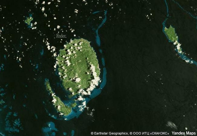
the town and its low line of buildings set among coconut and mango trees along the beach front was the first colonial capital of fiji, ceded to the british in 1874. it developed from the early 19th century as a centre of commercial activity by americans and europeans who built warehouses, stores, port facilities, residences, and religious, educational and social institutions around the villages of the south pacific island’s indigenous population. it is a rare example of a late colonial port town that was influenced in its development by the indigenous community which continued to outnumber the european settlers. thus the town, an outstanding example of late 19th century pacific port settlements, reflects the integration of local building traditions by a supreme naval power, leading to the emergence of a unique landscape.
6.8 M

Fiji
www.X-X-X.NAME
-17,68 ° × 178,83 °

17 ° 41 ′ 00 ″ S × 178 ° 50 ′ 04 ″ E
11.940.33 km

217 ° SW
Fiji, Eastern, Ovalau

Pacifiс Ocean / Melanesia / Fiji / Eastern / Ovalau
Sansa, Buddhist Mountain Monasteries in Korea

Asia and the Pacific

10.942.98 km
Complex of Koguryo Tombs

Pyongyang, South Phyongan Province, Nampho, South Hwangghae Province

10.785.88 km
Semmering Railway

Between Gloggnitz, State of Lower Austria and Simmering, State of Styria

7.417.91 km
Iwami Ginzan Silver Mine and its Cultural Landscape

Shimane Prefecture, Ohda City District

10.911.28 km
Great Zimbabwe National Monument

Africa

13.449.69 km
Konso Cultural Landscape

Africa

12.129.49 km
Wooden Churches of Southern Małopolska

Gorlice, Nowy Targ, and Bochnia counties, Voivodship of Lesser Poland (Malopolskie); Brzozów County, Subcarpathian (Podkarpackie) Voivodship

7.603.85 km
Persepolis

Fars

11.008.43 km
Mill Network at Kinderdijk-Elshout

Municipalities of Alblasserdam and Nieuw-Lekkerland, Province of Zuid-Holland

6.488.66 km
Caves and Ice Age Art in the Swabian Jura

Europe and North America

6.993.79 km
Routes of Santiago de Compostela in France

Regions of Aquitaine, Auvergne, Basse-Normandie, Bourgogne, Centre, Champagne-Ardenne, Ile-de-France, Languedoc-Roussillon, Limousin, Midi-Pyrénées, Picardie, Poitou-Charentes, and Provence-Alpes-Côte d’Azur

6.563.52 km
Roman Walls of Lugo

Province of Lugo, Autonomous Community of Galicia

6.074.23 km

©

1 X ™


BRAND COM CORP GLOBAL INT

AAA BASE GRAND HIGH ORIGINAL QUALITY TOP UNIQUE

X-X-X•NAME
1 X ™ unesco
Info
Map
similar
language
guest


1 X
-4
IP : America/New_York
-4
IP : America/New_York