xXx 1 X
unesco


Nan Madol: Ceremonial Centre of Eastern Micronesia

Asia and the Pacific

11.872.30 km
0

Nan Madol: Ceremonial Centre of Eastern Micronesia


Identifier 1503
states fm
category cultural
criteria (i)(iii)(iv)(vi)
Title nan madol: ceremonial centre of eastern micronesia
latitude 6.8397221565
longitude 158.3308258057
Region asia and the pacific
year 2016
unique number 2093
description 
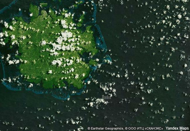
nan madol is a series of more than 100 islets off the south-east coast of pohnpei that were constructed with walls of basalt and coral boulders. these islets harbour the remains of stone palaces, temples, tombs and residential domains built between 1200 and 1500 ce. these ruins represent the ceremonial centre of the saudeleur dynasty, a vibrant period in pacific island culture. the huge scale of the edifices, their technical sophistication and the concentration of megalithic structures bear testimony to complex social and religious practices of the island societies of the period. the site was also inscribed on the list of world heritage in danger due to threats, notably the siltation of waterways that is contributing to the unchecked growth of mangroves and undermining existing edifices.
9.5 M

Micronesia
www.X-X-X.NAME
6.8397221565 ° × 158.3308258057 °

6 ° 50 ′ 23 ″ N × 158 ° 20 ′ 51 ″ E
11.872.30 km

64 ° E>NE
Micronesia

Pacifiс Ocean / Micronesia
Historic Centre of Salvador de Bahia

Bahia State, north-east region of Brazil

7.464.77 km
Kujataa Greenland: Norse and Inuit Farming at the Edge of the Ice Cap

Europe and North America

3.457.97 km
Belfries of Belgium and France

Europe and North America

6.482.55 km
The Grand Canal

Asia and the Pacific

11.563.22 km
Dazu Rock Carvings

Dazu County, Chongqing Municipality

12.216.74 km
Ksar of Ait-Ben-Haddou

Arab States

6.734.18 km
Umm Al-Jimāl

Arab States

9.843.44 km
Group of Monuments at Hampi

Karnataka, Bellary District

13.511.65 km
Qal’at al-Bahrain – Ancient Harbour and Capital of Dilmun

Northern Region

11.223.12 km
City of Valletta

Island of Malta

8.097.28 km
National Archeological Park of Tierradentro

Department of Cauca, in the jurisdiction of the municipality of Inza, in the “corregimiento” of San Andres de Pisimbalá

4.215.44 km
Ancient Jericho/Tell es-Sultan

Arab States

9.822.46 km

©

1 X ™


BRAND COM CORP GLOBAL INT

AAA BASE GRAND HIGH ORIGINAL QUALITY TOP UNIQUE

X-X-X•NAME
1 X ™ unesco
Info
Map
similar
language
guest


1 X
-4
IP : America/New_York
-4
IP : America/New_York